WHEN CLOUDS WEAVE MAGIC !
Wikipedia says : "In meteorology, a cloud is a visible mass of liquid droplets or frozen crystals made of water or various chemicals suspended in the atmosphere above the surface of a planetary body... Terrestrial cloud formation is the result of air in Earth's atmosphere becoming saturated due to either or both of two processes; cooling of the air and adding water vapor. With sufficient saturation, precipitation will fall to the surface; an exception is virga, which evaporates before reaching the surface."
I have always tried to study cloud formation with much interest and and also have read a few books and papers on them to enhance my knowledge. Cirrus clouds form at 10,000 m or 30,000 ft above the earth surface and look wispy and are made up of ice crystals which melt as they fall. Cumulus clouds appear soft and downy and they may be several kilometers thick and are formed by rising thermals. Stratus clouds are low, flat and extensive. Light continuous rain may be associated with them. Cumulonimbus clouds develop from cumulus when the top layers freeze. They bring snow and rain. In the tropics, they may be 20 km or 11 miles deep.
Shooting clouds do not demand an expensive camera or too many sophisticated lens or accessories. At the most, a wide angle lens fitted into an SLR may be helpful. You'll have to read the "cloud pattern", choose your composition and shoot. An occasional or deliberate underexposure by one to two stops may add more 'drama' into the cloudscapes... and that's all.
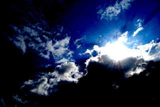
I am no specialist in this subject, but the clouds have ever attracted me in their various colors, shapes and formations and whenever possible, I tried to capture them with my camera. The pictures below were taken by me over a span stretching two years or more. Your comments/criticisms are always welcome and you may click the "comments/no comments" button below to register these.
Happy viewing...


Wikipedia says : "In meteorology, a cloud is a visible mass of liquid droplets or frozen crystals made of water or various chemicals suspended in the atmosphere above the surface of a planetary body... Terrestrial cloud formation is the result of air in Earth's atmosphere becoming saturated due to either or both of two processes; cooling of the air and adding water vapor. With sufficient saturation, precipitation will fall to the surface; an exception is virga, which evaporates before reaching the surface."
I have always tried to study cloud formation with much interest and and also have read a few books and papers on them to enhance my knowledge. Cirrus clouds form at 10,000 m or 30,000 ft above the earth surface and look wispy and are made up of ice crystals which melt as they fall. Cumulus clouds appear soft and downy and they may be several kilometers thick and are formed by rising thermals. Stratus clouds are low, flat and extensive. Light continuous rain may be associated with them. Cumulonimbus clouds develop from cumulus when the top layers freeze. They bring snow and rain. In the tropics, they may be 20 km or 11 miles deep.
Shooting clouds do not demand an expensive camera or too many sophisticated lens or accessories. At the most, a wide angle lens fitted into an SLR may be helpful. You'll have to read the "cloud pattern", choose your composition and shoot. An occasional or deliberate underexposure by one to two stops may add more 'drama' into the cloudscapes... and that's all.
I am no specialist in this subject, but the clouds have ever attracted me in their various colors, shapes and formations and whenever possible, I tried to capture them with my camera. The pictures below were taken by me over a span stretching two years or more. Your comments/criticisms are always welcome and you may click the "comments/no comments" button below to register these.
Happy viewing...


megh-er ami, megh-er tumi, :D
ReplyDeleteMegh diye jaaye chenaa. Thanks, Kausik Datta.
Delete